If you’re planning a holiday in Venice you’ll already have an idea of how you’ll arrive in the water-bound city. If you are flying, you can visit our airports pages to find details of transport into Venice. We’d recommend that you do a little research into local travel before you arrive in town. Venice’s layout is confusing and new arrivals frequently spend a long time wandering lost with their suitcases. Take directions to your accommodation (more advice below on this) and have a think about your travel requirements once you get to Venice: will you need to use public transport in town? Single boat tickets are very expensive and there are various types of travelcard and tourist card which can save money, and which you may want to purchase as soon as you arrive. See our public transport page for more information about travelling to and within Venice.
Geography
The main part of Venice is basically a large island in the Venetian lagoon, divided in two by the winding Grand Canal. The island is connected to the mainland by long road and railway bridges which run side by side over the water. If you are using land transport to reach Venice from airports or other parts of Italy, this is how you’ll arrive in the city. From Venice Marco Polo Airport, which is on the lagoon shore, you also have the option of arriving by water; catching a public ferry or a water taxi.
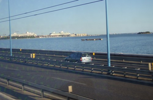
As you approach by the road or railway bridge, you will leave behind a singularly unattractive shore – the port area of Marghera. The nearest part of Venice, as you arrive, isn’t particularly pretty either. On the right you’ll pass the ‘practical’ bits of Venice, much of it reclaimed land: starting with the island of Tronchetto. Here there are car parks, moorings for cruise ships and ferries. Then, attached to the main part of Venice, stretching off to the south is the port area, with Venice’s only roads (they’re not public), railway tracks, and spots for loading barges. The railway veers to the left to terminate at Santa Lucia station on the northern side of the Grand Canal, while the road curves to the right to the set-down point for road traffic at Piazzale Roma, the other side of the canal.
If you can, try to see the view to the left as you cross the lagoon. On a clear wintry day the snow-capped Dolomites might be visible. Nearer at hand, in the lagoon, are the islands of the northern lagoon: large Murano (with a white lighthouse), Burano (further away, with a leaning belltower) and Torcello (a large barn-like cathedral). The Venetian shoreline you can see ahead to the left is of the Cannaregio district. The Cannaregio canal enters the city here, and used to be the city’s principal access from the mainland.
> Arriving in Piazzale Roma
> Venice public transport.
Arriving by car
If you are considering bringing a car, the best advice is simply not to do it. A car is absolutely no use once you’re in Venice; there are no roads. You really should spend longer than one day in Venice, and you will have to pay exorbitant prices for leaving your vehicle in a car park. If you are touring Italy or enjoying a two-centre holiday, pick up a hire car as you leave Venice, or check it in as you arrive. If you absolutely must bring a car to Venice, you will find the cheapest car parks on the mainland; you can then use public transport to get into Venice. There are big car parks on the new-ish island of reclaimed land which is to the right as you approach Venice over its lagoon bridge. This place is called Tronchetto, and is connected to the rest of Venice by public ferry services. Finally, there are expensive multi-storey car parks in Piazzale Roma, which is as far as you can drive into car-free Venice. (Although I have heard visitors at the tourist information office here insisting on directions for driving to their hotel).
Arriving by bus
Arriving by bus is straightforward. All buses to Venice terminate in Piazzale Roma. The only problem is finding your bearings once you alight – we’ve written a page of information to help: arriving in Piazzale Roma. Buses run to Venice from the mainland town of Mestre, from the city’s two airports and from many nearby towns such as Treviso and Padua.
By train
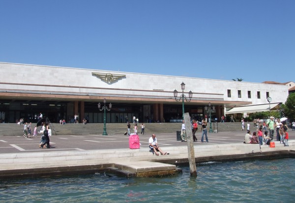
The long railway bridge was Venice’s first connection to the mainland, opened when the city was under Austrian rule in 1846. Among the buildings demolished to make way for a station was a church designed by Palladio, Santa Lucia. The station takes its name from the destroyed building, and is called Venezia Santa Lucia. It is located on the northern side of the Grand Canal, at the western end of Venice.
Don’t get off at the mainland station of Mestre by mistake (it’s called Venezia Mestre; trains often empty here as local people alight). After Mestre the train continues past the smaller stop of Porto Marghera (only a few services stop here) and over the ninteenth-century railway bridge to the terminus, Venezia Santa Lucia. The modern station building, which dates to the 1950s, has a large open hall where there are a few souvenir shops, news-stands, a snack bar and a very small tourist information office. It opens onto a flight of steps facing the Grand Canal, and there is a row of vaporetto stops, along with a ticket kiosk, directly in front of the station building. The name of the ferry stop here is ‘Ferrovia’, which means railway. To your left as you leave the station there is a bridge over the Grand Canal (the Ponte degli Scalzi) – cross this for the Santa Croce district, turning right along the water to reach the bus station at Piazzale Roma. If, instead of crossing the bridge, you continuing to the left along the station shore, you’ll find yourself on a major thoroughfare which passes through the district of Cannaregio towards the Rialto, around 30 minutes’ walk away.
By boat
From Marco Polo Airport there are public ferry services to a variety of spots around Venice – it’s more expensive than catching a bus, but may deposit you nearer to your hotel (thus saving on additional vaporetto tickets). Take a map and see our notes below on finding your way to your hotel.
Water taxis
Water taxi is the smartest way to arrive in Venice, although you will be limited by whether your hotel has a landing stage. If not, the taxi will drop you at the nearest canalside, so finding your way shouldn’t be a problem. You can catch water taxis at Marco Polo Airport.
Finding your hotel or apartment
Since it is so difficult to find your way around Venice, hotels are usually good about giving directions. Make sure you print these out and carry a map. The best directions will include landmarks, bridges and descriptions as well as street names. Venetian addresses consist only of a district and a house number, so are little use for navigating. Find out the hotel’s recommendations for arrival (which vaporetto stop to use, whether to walk). Your first hour in Venice, with heavy luggage, isn’t the best time to strike out on your own.
If you are staying in a small B&B or a holiday apartment, try to form arrangements for arrival in advance. Usually the owners have a day job and will make an appointment to meet you at a nearby vaporetto stop and escort you to your accommodation. If you are telephoning them from a mobile phone or pay phone, note that in Italy you always dial the area code, and include the initial zero.