The promontory of Portofino
 Between the resorts of Camogli and Rapallo, the long smooth line of the Ligurian coast running down from Genoa is interrupted by a square headland, about three miles each way, with Santa Margherita and Portofino along its lower edge. The interior is a forested ridge, rising more than 1500 feet (500 metres) above the sea. This descends steeply, through rock and Mediterranean scrub, to the outer (south-west) shore of the promontory. There are no roads and hardly any habitation along that wild coast. Elsewhere, the ground slopes more gently and is more domesticated, although not built-up. Most of the promontory is a protected zone – the Parco Regionale di Portofino – where the natural environment has absolute priority over development.
Despite that, the four resorts around this protected reserve – Camogli, Portofino, Santa Margherita Ligure and Rapallo – are connected by good bus services (typical fare 1.50 euros), and the promontory as a whole is served by a well-maintained system of footpaths.
How to get to the Portofino headland
Camogli, Santa Margherita and Rapallo are all on the main railway line between Genoa and Pisa. However, travellers arriving by rail should check whether they need to change, because most trains don’t stop at all these stations. Allowing for that, the journey might take up to an hour from Genoa, two and a half hours from Pisa. By car it’s about 20 miles (30km) from Genoa, 70 miles (110km) from Pisa and 100 miles (150km) from Milan. In each case the drive is mainly along Italy’s major autostrada network.
About the Parco Regionale and its district
The authorities have successfully limited (so far at least) the outward and upward growth of the four resorts, and of Recco a mile or two further along the coast towards Genoa. There is plenty of scattered settlement among the hills in the usual Italian style, comprising a mixture of villas and farms; olive terraces and citrus groves; churches and sanctuaries; a few vineyards. But the skyline is always forested. For example, there’s no rash of modern villas-with-swimming pools spoiling the hillside above Portofino. The four resorts vary markedly in character. If there is a dominating theme in the architecture – and this includes even the more isolated villas and churches – it’s the charming trompe-l’oeil (‘deceive-the-eye’) painting of exteriors: buildings are adorned with statuary, columns, balconies, friezes, garlands and pediments but these have merely been painted on. This seems to be a long-standing tradition, from the 17th century down to the present.
Another feature, more sporadic but a good deal older, are the tower-houses. In the days when the Genoese coasts were threatened by Turks, corsairs, Venetians and other enemies, thick square towers, battlemented at the top, were built either by the shore or with a more distant view of the sea. Many of these survive, several centuries old but turned (usually) into rather fine homes. They aren’t always obvious, because they may now be part of a larger building – sometimes a villa with trompe-l’oeil decoration!
The dominant rock of the headland is a hard conglomerate, in which large pebbles and stones have been compressed together through the effects of time and pressure. This forms craggy ground where it is most exposed to the baking sun and salt winds, but elsewhere tends to break down into a dark soil. The natural vegetation on higher ground is holm oak, a low evergreen species, along with some Mediterranean pine, but this is replaced by deciduous oak and sweet chestnut in the cooler and damper conditions of the summits and northern slopes.
The promontory is reckoned to be rich in wildlife, including boar and both migrant and resident bird species – with peregrine falcons along the cliffs – although this wasn’t obvious at the time of year (March) of our main visit. There is also a marine reserve, to protect fish, cetaceans and sea-bed flora and fauna. In contrast, sandy beaches are scarce. This coastline is generally better for the scuba diver than the sunbather.
Footpaths on the headland
It will be no surprise to our readers that we have explored the opportunities for gentle exercise in this attractive district. The good news is that walking in the Portofino promontory takes precedence over driving. The authorities support their network of footpaths, most of them former mule-tracks, as a distinctive feature of the area. They are well looked after, well signposted and well publicised on notice-boards giving information about the Parco Regionale. The beginnings of the walks, starting in the towns, aren’t always clear, but once on the way you should meet few problems. There are painted waymarks, coded according to the route, and signposts at junctions. Expect many flights of steps.
You do, of course, need a map to make full sense of the system. Sheet 131 of the Freytag-Berndt series (1:50,000), which covers both the Cinque Terre and the Portofino district, is a good buy if you want both areas, and it has some useful notes on the resorts and some of the footpaths in four languages, including English (buy from Amazon.co.uk: Cinque Terre: FBW.WKI.31: Walking Map). However, for the Portofino district by itself, the leaflets and maps available free from tourist offices and some hotels are just as good. We used (in 2009) Vie e Sentieri del Monte di Portofino and In the Promontory of Portofino between Sea and Land. With either leaflet, and perhaps a bus timetable, you can work out a walk lasting anything between an hour or two and a full day. The paths tend to be either hard-surfaced, with a few stretches on tarmac, passing villas, smallholdings, olive groves and scraps of woodland, or alternatively rough paths through forest and across rocky hillsides. They can be energetic routes, but the whole district isn’t vast; and you aren’t likely to be lost for very long.
One or two specialist guides to the Parco Regionale have been published, but we failed to track these down in our limited trawl through local bookshops and kiosks and preferred instead to discover what the area has to offer at first hand. We tested the footpaths on two particular routes, and provide the following details on what we found.
Route 1 – Santa Margherita to Portofino. Moderate (wear good shoes) – 2 hours
We start by walking up Salita Montebello, a road which heads inland from the vicinity of the long quay at the southern end of the harbour. Before long, and still climbing, the route narrows to a wide footpath of steps and cobbles, with clear waymarking. There are a few yards on quiet motor-roads, but the way mostly goes through pleasantly mixed country, with holm oaks, terraced olives and wild flowers. The places indicated on the signposts are hamlets or chapels (like Madonna della Neve and Gave, which we pass) but the more distant targets – Paraggi and Portofino in our case – are consistently named too. There are some quite steep gradients but these are only loose or damp where there is work going on , mostly to maintain the footpath itself , and we keep getting good views, especially leftward, down towards the sea and back across Santa Margherita to the long and mountainous coastline running south towards La Spezia.
After an hour and a half, the path descends to a small car park just above the pretty beach and restaurant at Paraggi. Here we follow the road to the right but almost immediately find a notice directing us up onto a rather smart path of brick and tile, with comfortably graded steps and even some ceramic signposting. This is easy going now, above the road all the way (half an hour), past the further little beach of Niasca, to Portofino, where we debouch neatly onto the black-and-white mosaic forecourt of the church. Total distance 3.5 miles (6 km) with about 700 feet (200 metres) of climbing.
The quay and restaurants lie a couple of minutes down to the left. If you fancy further exertions, you can get out to the Faro (lighthouse) and viewpoint in another half-hour. There are regular buses back through Paraggi to Santa Margherita from the car-park five minutes up from the seafront, past a little food shop. If you are unable to buy a ticket from the tabacchi (it was closed when we arrived) you can do so from a slot machine by the bus stop. The alternative more coastal ‘path’ from Santa Margherita to Paraggi mostly follows the road but does have some interest. On the outskirts of Santa Margherita it passes one or two extravagantly convoluted – almost insane – mansions behind high walls and, on the left by the beach, the Covo di Nord Est, now a rather run-down-looking discotheque but once a famous night-club which catered for Europe’s fun-loving rich.
Route 2 – Camogli via San Fruttuoso to Santa Margherita. Tough (wear boots) – 5 hours
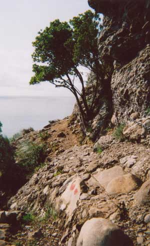
A good head for heights and a firm grip are also necessary. We head south out of Camogli along a tree-lined road, past carabinieri offices, and pick up the signposted footpath at its end. This leads on and steeply upward in broad concrete steps, through trees and past houses. After half-an hour the way eases, skirts right, past the handsome domed church of San Rocco, and emerges high above the sea, where it continues above steeply-wooded slopes with a big view back over Camogli and (if clear) far beyond Genoa. An easier and slightly shorter route is signposted left for San Fruttuoso but connoisseurs should keep to the path blazed with two round spots. This becomes woody, undulating through holm oaks, with the protection of a handrail whenever it crosses steeper ground.
More drama is to come, the best on the promontory. The trees thin and the path dwindles to a mountaineer’s version, thread-like, traversing rocky scrub. We reach an old German gun battery in a superb situation, ideal for a picnic, but there’s also a notice here in Italian, warning that the route ahead is a very committed one, with a nervy passage – Passo del Bacio (Pass of the Kiss) – across cliffs, assisted by fixed chains. Take this seriously, because there are several places coming up where the footing is not particularly supportive and the rock below rather precipitous. Each has chains to hold on to. They can be fun, but you must not get stranded between these ‘bad steps’, so if the rocks are wet or you begin to feel very worried turn back and switch to one of the signposted alternatives.
Going ahead is slow progress, as the chained sections need time and care, and the path (keep looking for the two spots) is sketchy, with sharp ups and downs. An ancient watch tower stands on a wild headland, the last one before San Fruttuoso, but instead of going out towards it the track now bears uphill, zig-zagging through the pines and holm oaks. After a climb of almost a thousand feet (300 metres), we briefly level off then zig-zag all the way down again, reaching to within a few yards of a platform just offshore, by the edge of a shingle beach. Three hours have passed since Camogli. Welcome to San Fruttuoso – you’ll find it a remarkable place.
The next leg of the route starts the other side of the monastery, on the way to a bar built over the water. The two-spot route would take you up and east – eventually to Portofino – so ignore this and search for the single circle which marks the way to Pietre Strette. This is an old stepped path which zig-zags up through light woodland away from the sea and past a farmhouse which sometimes doubles as a restaurant, near which some old and overgrown olive terraces are being resuscitated. After a climb of 1,500 feet we arrive at the major path junction of Pietre Strette (‘Narrow Stones’). This is set on the summit of the forested ridge which crowns the whole promontory, at its narrowest point. You can, indeed, see what might be the original narrow stones nearby, where a steep gully cuts down to the north.
The environment here is radically different – more often beset by mist and moisture. We are in temperate forest as we take a dirt road to the right (waymarked with two triangles) and then a smaller path descending half-left, signposted to Santa Margherita. The two triangles lead us onward, heading straight for the town as we emerge from the forest and begin to pass smallholdings and villas. Things become more suburban, the cobbles turning increasingly into concrete steps and eventually tarmac. Houses down passages both to right and left are assigned addresses numbered as belonging to Strada (or Via) Costa Secca, but the two triangles continue to reappear and it is from the Via Costa Secca that we eventually emerge (two hours after leaving San Fruttuoso) into a corner of Piazza Mazzini in the town centre.
7 miles (11km) with about 3,500 feet (1,000 metres) of climbing.
Buses run frequently between the nearest part of the seafront to Piazza Mazzini/Piazza Caprera (ticket kiosk nearby) and Camogli. In Camogli they go beyond the town centre as if heading straight for Recco before turning back to a more definite halt near the railway station and information office.
Longer walks in the Portofino area
Inland from the Portofino promontory there are further options for the walker. These may lack the detail and charm as well as the close waymarking of the promontory but might interest those wanting more and bigger challenges. One possibility is to trace a long arc across high ground, much of it forested, from Rapallo to Recco (a little way west of Camogli and connected by bus), combining two or three waymarked routes. By our calculation – without walking it ourselves – this must be around 10 miles (16 km) long and take a full day to walk. Further inland still are the Ligurian (or Genovese) Appennines, the wave-like ridges of which rise above the forests, with alpine flowers and big views. According to local information, this has long-distance footpaths as well as some interesting destinations, if you have the transport to get you there.
Report and photographs by AH
On this site
Useful external links